Investigating The Himalayas
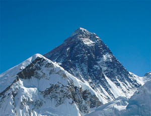
Mount Everest, the tallest mountain in the world, is located in the Himalayas.
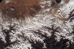
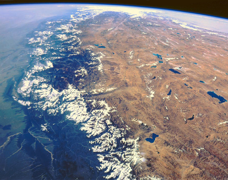
This satellite photograph is taken over the northern border between the countries of India and Nepal. This particular image captures part of the tallest mountain range in the world: the Himalayas. The Himalayas are home to the world's tallest mountains. In fact, the top 100 tallest mountains on Earth are located in the Himalayas. The mountain range spans approximately 2400 kilometers, or a little over half the average width of the United States. The highest peak in the Himalayas is Mount Everest, which reaches almost 9 kilometers above sea level (commercial aircraft cruising altitude). The Himalayas began to form around 70 million years ago when the country of India, then its own separate land mass in the Indian Ocean, collided with the Asian continent. India is still pushing inwards making the mountains in the Himalayas grow taller every year.
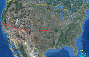
The Himalayas stretch over half of the United States.
This satellite image contains several mountains, rivers and glacial lakes. The elevations range from 2000 meters in the valleys and crevasses to 6000 meters at the peaks. With satellite imagery it is often hard to determine the elevation of a location if there are no landmarks or particularly defining features nearby. Luckily, this image is taken in a location where there is an abundance of snow. It is easy to see the snow line around the various mountain peaks in this image. There are two types of snow lines:
climatic and
actual. The climatic snow line is the elevation (and above) at which snow and ice cover the terrain year round. The actual snow line varies throughout the year according to the season. Usually the climatic snow line is the actual snow line during that location's summer season, when it is warmest.
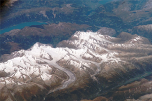
An easily visible snow line. There is an elevation at which the snow begins to stick to the mountainside.
However, these are not strict rules; the snow line also depends on how close the location is to a coast in addition to the altitude and latitude of that particular site. The climatic snow line in the Himalayas, which reside around 30°N latitude, is approximately 4800 – 6000 meters.
But wait! Our image contains peaks that max out around 6000 meters yet there is plenty of snow. Why is that? Well, our image was also taken in the winter when the actual snow line would be considerably lower than the climatic snow line. Even if we do not know the particular elevation of a satellite image that we are examining we can still glean useful details from the snow line. In this way, the snow line acts a little bit like the contour lines on a topographical map. If we know some details about the site's location and the season the image was take we can discern some details about how high a peak reaches or how deep a crevasse runs. It's important to remember that at a particular time of year the seasons in the North and Southern Hemispheres are opposites (e.g. when it is winter in the Northern Hemisphere it is summer in the Southern Hemisphere).
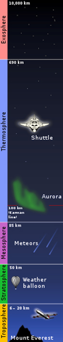
Atmospheric levels.
In addition to elevation one of the greatest factors with regards to whether or not snow will stick to the terrain is the temperature. Within the
Troposphere (the lowest level of the Earth's atmosphere – from sea level to around 20 kilometers), temperature decreases with increased elevation. It is common for temperatures towards the top of the Troposphere to be appropriate for snowfall but too warm towards sea level for the snow to fall. At a particular elevation, due to many factors such as temperature, season, terrain steepness and geographical location, snowfall will no longer stick to the terrain and will create the snow line. Satellite imagery is a great tool for understanding the Earth's topography and seasonal/yearly changes to geography, but sometimes we have to use clues in the photograph to help us understand what it is we are seeing.
The entire Himalayas as seen from space.