


Investigating Santa Fe, Argentina

Geography
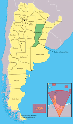
Argentina is a country in South America with a very diverse land and culture. It includes arctic regions in the south, forests, grasslands and jungle regions in the north, an Atlantic coastline on the east, and mountain regions in the west. With an area around one million square miles, Argentina is the fourth largest country in the Americas; only Canada, the USA, and Brazil are larger. It is the seventh largest country in the world. Santa Fe is a province in the northeastern part of Argentina.Along the west of Argentina runs the Andes mountain range, forming a natural border with Chile. The Argentinean Pampas (plainlands) lie to the south of the Rio de la Plata, meeting the Atlantic Ocean to the east. They are covered by deposits of silt, loose soil, sediments, and volcanic ash. These nutrients are transported to the plains by rainfall, wind, and following successive periods of glaciation. Glaciation is a time during an ice age where glaciers will move large distances, often bringing soil nutrients along with it.
Activity: Locate the general area of the Andes mountain range on the map provided.
Questions: Which countries border Argentina? What major ocean does Argentina touch? Can you name a country in the world that is larger in land size than Argentina?
Paraná River
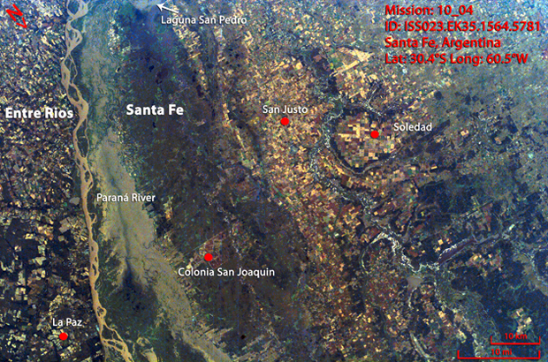
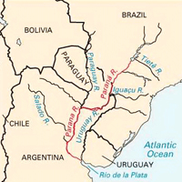
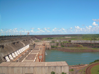
The Paraná River runs through Brazil, Paraguay and Argentina, and is about 5,000 kilometers long. It is the second longest river in South America. The Paraná River serves as the natural border between Brazil and Argentina; you can find this border on the map above. The Paraná River gets its name from the native phrase "para rehe onáva", meaning "as big as the sea". It is connected to the Paraguay River and the Uruguay River which creates the Río de la Plata, running into the Atlantic Ocean. The Paraná River is home to the Itaipu Dam, the second largest hydroelectric power station in the world. A hydroelectric power station is used to produce energy for electricity from moving water, commonly rivers.The Paraná River is connected to open sea through the Río de la Plata. There are also other tributaries to the Paraná including the Salado del Norte, the Carcarañá and the Arroyo del Medio. A tributary is a small river or stream which stems from a larger river. Tributaries do not have a direct connection with oceans or lakes. Tributaries are important for draining large areas of land. Without these tributaries, the plainlands would flood after heavy rains.
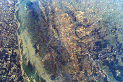
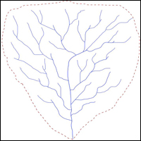
The Paraná River along with its tributaries creates a massive watershed that spreads throughout northern Argentina. A watershed is an area of land where water is collected, often from many sources (rain, rivers, etc.). A large part of the Paraná River is suitable for travel by boat, and is used to connect people from the inland cities of Argentina to the Atlantic Ocean and Buenos Aires, Argentina's main sea port. People and animals often live near rivers for food, water, transportation and protection. This is why the people of Santa Fe live near the Paraná River and its tributaries. Although rivers are a source of life, they can also be very destructive: flooding can cause destruction for people living too close to the riverbanks, whose homes and food crops may be ruined when the water level rises too high.
Activity: Locate the Paraná River in the annotated image of Santa Fe as well as on the map provided. Also locate where the majority of the people live from studying the annotated image. Why do you think most of the people live near rivers?
Questions: If the Paraná River is the second longest river in South America, which is the longest river in South America?
Rio de la Plata (Plate River)
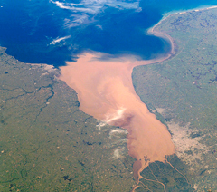
The Rio de la Plata (Plate River) is a large estuary formed at the junction of the Paraná River and Uruguay River. An estuary is a body of water on the coast which is connected to a river or stream which flows freely into the ocean. The water in a river is called "fresh water". It comes from rain or snow and it can usually be drunk safely, unless it has been polluted. The water in a sea cannot be drunk safely because it is "salt water". The amount of water flowing into the Atlantic Ocean through the Río de la Plata is roughly equal to the amount of water flowing from the Mississippi River into the Gulf of Mexico.Activity: Observe and locate the estuary in the image above; notice the visible difference in water color (why does this happen?)
Questions: is the water in an estuary saltwater, freshwater, or a combination of both? Do you think this affects the animals living in the estuary?
Climate
Argentina experiences many different types of climates, since it is such a large country covering a large portion of South America. Santa Fe has a moderate climate with an average temperature of 19°C and annual average precipitation of up to 1.1 meters, although Santa Fe experiences a distinctive dry season throughout the winter. These conditions are ideal for agriculture.Activity: Find the latitude of Santa Fe.
Questions: What other countries might have climates similar to Santa Fe? (Hint: look at other countries at the same latitude of Santa Fe). How do you think these weather conditions affect they way the people of Santa Fe live?
People
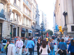
Argentina is a partially urbanized nation whose population lives in or around the cities of Buenos Aires. Argentina has a population near 40 million people; around 3 million of these people live in Santa Fe. The people are largely Mestizo or of European origin. Mestizo is the name given to people who share both European and Native American ancestors.Questions: how does the population of Argentina compare to the population of your home country? Is Santa Fe home to more or less people than your own home province/state?

Economy
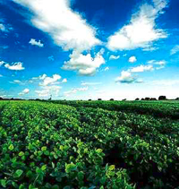
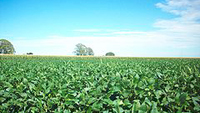
The Paraná River and its tributaries provide income and livelihoods for fishermen living on its banks in Santa Fe. Agriculture is also a big part Argentina's economy. If you observe the image of Santa Fe closely, you will notice that the plots of agricultural land are grouped closely around the several rivers seen in the image. The plains of the Pampas are used to grow rice, and are also herding grounds for cattle which produce the country's meat and milk to be sold throughout Argentina and around the world. Wheat and fruit are Argentina's other major agricultural products. A wide range of soft fruits, citrus fruits, and more specialized crops such as grapes for wine, along with walnuts, are grown in Argentina's central valley. Santa Fe's economy is 8% of the total Argentinean economy, which is the fourth largest in the country. 21% of the cultivated lands of Argentina are in Santa Fe, whose main crops are soybeans, sunflower, wheat, and other types of grain. Manufacturing is also popular in Santa Fe, and is also among the top in Argentina. Mills that produce different flours, oils, and other food products are widespread in Santa Fe.Activity: Locate the agricultural plots in the annotated image of Santa Fe.
Questions: Why do you think that the agricultural plots are grouped around the rivers and lakes in the image?

