


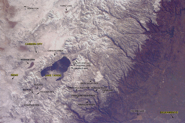
Investigating The Sierra Nevada Mountains and Lake Tahoe
The region now occupied by the Sierra Nevada Mountains once lay beneath the sea, receiving sediment from the North American continent to the east. Through the process of plate tectonics, the Pacific Plate crashed into the North American Plate and was subducted beneath it. The incredible force of the crash caused the sediment to melt, forming an enormous magma chamber which eventually cooled to form granite. These forces additionally caused the uplift of the land, forming enormous mountains. The process of erosion has since removed the sediment layer above the granite, exposing the sierra that we see today. Continuous movement of the plates caused additional uplift, melting and folding that produced a mix of sedimentary, metamorphic and volcanic rock that can be seen today.
About 30 million years ago, an era of volcanism of massive proportions began in the sierras. During this era, the sierra began uplifting again to form many parallel faults. The area to the west rose while the area to the east (now Carson Valley) dropped. The Tahoe Basin, like Carson Valley, has dropped between two uplifted blocks; the Sierra Crest on the west and the Carson Range on the east. Volcanic activity occurred frequently just north of the lake, and a lava flow eventually crossed over the Carson River. This dammed the valled and formed Lake Tahoe.
The area to the east of the range is referred to as the high desert. At elevations ranging from four to six thousand feet, this flatland receives very little rain because the peaks of the Sierra Nevada block precipitation flowing from the west (the ocean). Although this area is desert, it still remains very cold in the winter, and snow frequently covers the area.
The area to the west of the range is California's central valley, the primary home of the state's agriculture. However, in this picture, one of California's most important cities is also visible-Sacramento.
Lake Tahoe
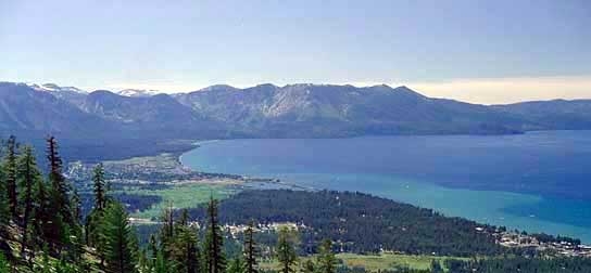
Lake Tahoe
A view of the bottom.
Carson City, Nevada
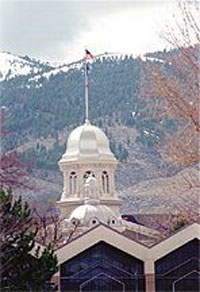
Carson City's Capitol Building
Gold and silver mining remained a prosperous activity in Carson City for many years. The United States Mint in Carson City was built in 1869, and today it is the site of a museum. When the metal mining grew thin, timber mills kept the economy going. Today, the city is located conveniently close to Lake Tahoe and Reno, allowing the city to maintain a thriving commerce from tourism.
Reno, Nevada
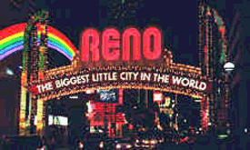
Reno lights
In 1927, the transcontinental highway system came to town. In celebration, the town erected an arch across Virginia Street, welcoming visitors to "The Biggest Little City in the World." The idea stuck. Today, the fourth generation of the famous Reno Arch greets the millions of visitors who flock to the city each year.
Hit hard by the Great Depression, Nevada took a chance in 1931 and became the first state to legalize gaming. It was a gamble that would pay off big for the growing town of Reno.
The Truckee River allows those who do not wish to gamble the opportunity to still enjoy themselves. Carrying Lake Tahoe's crystal clear waters, the river meanders its way through the town, offering rafting and a good peek at wildlife within mere feet of ringing slot machines. Geese and ducks can easily be seen bobbing along the gentle rapids.
Sacramento, California
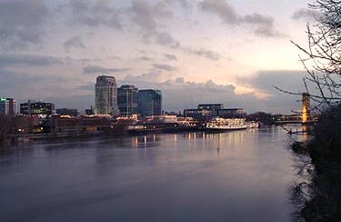
The city over the Sacramento River.
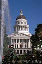
California's Capitol Building.
In 1848, a discovery at Sutter's Fort (which is about 50 miles from the current downtown) changed the Sacramento frontier forever. Gold was found by a contractor at John Augustus Sutter's lumber mill. Sutter tried to keep the discovery secret, but the news soon spread to San Francisco, and the gold rush was on. By 1850, Sacramento had a population of 9,000, and was an important city in the growing west.
California became a state in 1850, and by 1854 Sacramento was the state capitol. In 1860, Sacramento was designated the western terminus of the Pony Express. In 1863, the first track for the transcontinental railroad was built, which would link the east and west coasts. When the railroad was finally completed in 1869, the city began to grow and prosper.

