


Investigating The Valdes Peninsula (another look)
Boasting to be the second largest South American country and the eighth largest in the world, Argentina is home to the vast Andes Mountains and is approximately 1,068,302.7 square miles (a little less than 30% of the US)1. Argentina like the United States is known to be a melting pot of cultures as much of its population can be attributed to European (86.4%), Mestizo (8%), and Asian/Arab (4%)2. In fact the capital of Argentina, Buenos Aires is referred to as the Paris of South American because of how cosmopolitan it is2. The capital is home to one of the largest opera houses in the world, Teatro Colon, and also contains the neighborhood La Boca, which birthed the famous dance style, Tango and now contains beautiful museums and works of art along its streets2.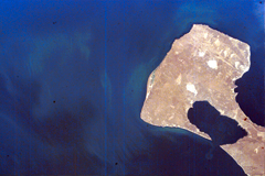
Checking For Understanding
Please use the satellite image to answer the following questions. Click here to view the original image.- The image is an example of/exemplifies which of the following?
- an island
- a peninsula
- delta(s)
- lake(s)
If you guessed correctly, you guessed (b) and (e). This image does not exemplify an island because the land is not completely surrounded by water. This image also does not contain a delta because a delta must have rivers which clearly are not visible. There are salty lakes present in this image as indicated by the little white specks that dot the peninsula.
- This image shows that the Valdes Peninsula is linked to the Patagonian mainland. By looking at the textures and colors present in this image you would guess that the peninsula is:
- Barren plain
- Agricultural
- Forestland
The correct answer is that the most of the land is barren because of the dry, dull, and uniform color that the peninsula possesses. Had this been an agricultural area there would be more variations in color and if this were forestland the area would be predominantly green.
- Is there a coastline in this image? How do you know?
Yes there is a coastline in this image. The coastline is what separates the mainland from the Atlantic Ocean.
- Is the peninsula surrounded by gulfs?
The correct answer is yes, there are 2 gulfs. To see where exactly these gulfs are view the image of the peninsula below.
The Valdes Peninsula and Puerto Pirámides
As mentioned before, this peninsula is exceedingly barren. It so barren in fact, that the ONLY town on this peninsula is the small one known as "Puerto Pirámides"3. Interestingly, this town was named "Puerto Pirámides" by settlers because of the pyramidal shaped cliffs that are sprinkled along the Argentinean coastline3.Contained in the northeast portion of Argentina, the Valdes Peninsula is part of the Chubut Province3. The peninsula was once exploited for its valuable salt mines in 1898, but today is an important nature reserve as defined by UNESCO in 19913. Some of the marine mammals that inhabit this area include sea lions, elephants seals, fur seals, (along the coastline), southern right whales (in the Golfo Nuevo and Golfo San Jose), orcas (off the coast), and rheas, guanacos, and maras (in the peninsula)3. Whales typically arrive between May and December as the water is warm and quiet thus promoting their mating and birthing seasons3. Orcas tend to lurk near the coastline as it provides a mall of elephant seals, sea lions, and penguins that it can procure for food3.

